

Welcome to the Coors Corridor Sector Plan Project Website!
We’re excited to have you here as we work together to shape the future of the Coors Corridor. This website is your hub for all things related to the proposed Sector Plan. Explore the latest updates, share your ideas, and learn how you can get involved in creating a vibrant, connected, and sustainable corridor that meets the needs of our community. Your input is invaluable in this process, and we look forward to hearing from you as we plan for the future of the Coors Corridor.
Review the Most Relevant Documents here.
-
 South Coors Sector PlanPDF (11.81 MB)
Review the County Planning Commission version of the South Coors Sector Plan.
-
Existing Bernalillo County Base Zones: Listed UsesPDF (1.17 MB)
The South Coors Boulevard Sector Plan introduces two new zoning categories: SD-SC-AC (“Activity Center”) and SD-SC-C (“Corridor”). These zones are derived from existing Bernalillo County zoning districts and incorporate permitted uses from the O-1 (Office and Institutional), C-1 (Neighborhood Commercial), and C-2 (Community Commercial) zones. This document summarizes the uses allowed within each zone. Please note that both the County Zoning Code and the South Coors Sector Plan include additional regulations, conditions, and requirements associated with these uses. For complete information, refer to the full text of each document.
-
South Coors SP Neighborhood Association Presentation Fall 2025PDF (4.69 MB)
Presentation shared with impacted neighborhood associations in fall 2025 that provides project information.
PROJECT PURPOSE
The South Coors Corridor Sector Development Plan is intended to create new mixed-use centers along a major transit corridor and within walking distance of nearby neighborhoods. The plan focuses on promoting diverse housing options and fostering a range of economic opportunities, particularly within designated Centers, which are defined both by higher-level planning frameworks and through the planning process itself. The goal is to create a more coordinated land use context that supports a safer, multi-modal streetscape along Coors Boulevard.
This project compliments a concurrent Coors Roadway Safety Project, conducted by WSP, to reimagine a portion of the corridor to be a safer, more walkable, and transit-friendly regional corridor. More information regarding that project can be found on their project website: https://safercoorsblvd.com.
The Sector Development Plan is a long-range plan that will establish an overall redevelopment vision for the Plan area and specifically addresses following topics:
- Sustainability implications and practices
- Land Use / Zoning
- Transportation
- Housing
- Economic Development
- Utilities
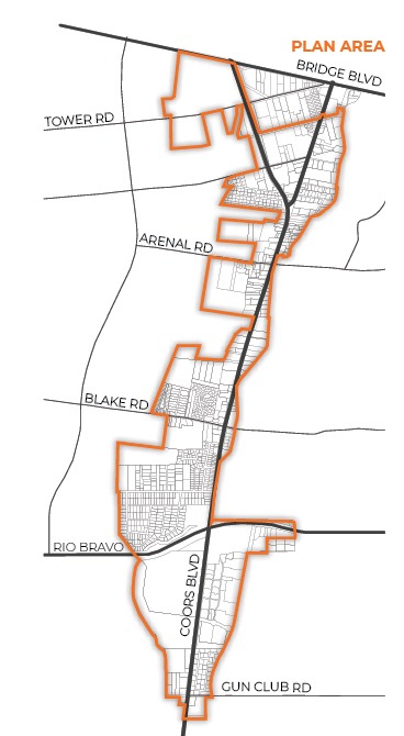
PLAN AREA
The project area consists of approximately 1277 acres and is roughly bounded by Bridge Boulevard SW on the north, Gun Club Road SW on the south, the Amole del Norte Channel on the west, and the Arenal Canal to the east. The area does not include parcels under the City of Albuquerque’s jurisdiction, most notably the Walmart and the Rio Bravo Square commercial Center, both located at the intersection of Coors Blvd and Rio Bravo Blvd and several parcels along the Amole del Norte Channel on the west.
PROJECT PROCESS
The planning process initiated in the summer of 2024 and will be conducted in four major phases:
- Phase 1: Discovery, initiated in Summer 2024, is conducting fact-finding to determine baseline conditions in conjunction with public engagement to determine corridor issues, needs, and opportunities that the Plan will address.
- Phase 2: Visioning, occurring in Fall 2024, will utilize a community survey to generate consensus around new goals and policies for the six plan elements (sustainability, land use / zoning, transportation, housing, economic development, and utilities) that will ultimately guide the redevelopment vision of the Plan area.
- Phase 3: Synthesis, happening in Winter 2024, will develop the content for each of the six plan elements that aim to implement the vision generated in Phase 2. The draft plan generated during this phase is anticipated to be released in January 2025 and will be presented through a public open house.
- Phase 4: Plan Review / Adoption cycle, anticipated to initiate in spring 2025, provides an additional opportunity for the public and governing bodies to review, vet, and ultimately approve the final plan.
24 October, 2025
QQ says:
More lanes means more traffic! Better busses that runs later, come more frequently, and is convenient to walk to will be better for climate
24 October, 2025
QQ says:
Middle scale housing like duplexes and multifamily units might seem ugly to some, but very needed for working families to afford living here
2 July, 2025
Ernesto says:
Storm drain on Barcelona sw and Coors and sidewalk and a senior center
27 June, 2025
Olga says:
The idea of a beautiful park is pleasing. We do need for Denis Chavez to have two lames each direction. Thank you.
27 June, 2025
Marci says:
A bike lane is not as needed as Denis Chavez road to have 2 lanes each way. Also, a nice park like North Domingo Baca.
30 April, 2025
Jacqueline says:
I like the idea of over head bridge path ways on south coors. Please finish one road before starting another. No apartment complexes!!!
25 January, 2025
Etta says:
Street lights from Rio Bravo Blvd south to El Malpais as speeding is a big problem and visibility for walking or bikes is dangerous.
18 January, 2025
Shirley says:
Finish Rio Bravo and Bridge Blvd Main Arteries before you tear up another road in the South Valley!!
14 January, 2025
LJ Vigil says:
add local grocers/commercial businesses that pay county NMGRT, at present the only shopping available displaces community taxes to the CoA.
11 January, 2025
Bryce says:
We need a tractor supply out here. Entertainment is needed, bowling and billiards would be great. A local bar that stays open till 12am too
11 January, 2025
Stone says:
We need a hardware store other than RAKS like an ACE or Home Depot. A rodeo arena would be great. A local brewery would be nice too.
11 January, 2025
SM says:
More businesses like Target, Lowe’s, Costco and local businesses while also preserving agricultural areas. A co-op for farmers would be cool


